

FULL RESEARCH ARTICLE
Christina M. Aiello1*, Nathan L. Galloway2, Kristin Fratella3, Paige R. Prentice1,4, Neal W. Darby5, Debra L. Hughson5, Clinton W. Epps1
1 Oregon State University, Fisheries Wildlife, and Conservation Sciences, 104 Nash Hall, Corvallis, OR 97331, USA
![]() https://orcid.org/0000-0002-2399-5464 (CMA)
https://orcid.org/0000-0002-2399-5464 (CMA)![]() https://orcid.org/0000-0001-6577-1840 (CWE)
https://orcid.org/0000-0001-6577-1840 (CWE)
2 National Park Service, Biological Resources Division, 1201 Oakridge Drive, Suite 200, Fort Collins, CO 80525, USA![]() https://orcid.org/0000-0002-0614-2988
https://orcid.org/0000-0002-0614-2988
3 Oregon Department of Fish and Wildlife, 1850 Miller Island Road, Klamath Falls, OR 97603, USA
4 California Department of Fish and Wildlife, Wildlife Branch, 1010 Riverside Parkway, West Sacramento, CA 95605, USA (current)
5 National Park Service, Mojave National Preserve, 2701 Barstow Road, Barstow, CA 92311, USA
![]() https://orcid.org/0000-0002-3707-1836 (DLH)
https://orcid.org/0000-0002-3707-1836 (DLH)
*Corresponding Author: christina.aiello@oregonstate.edu
Published 28 March 2024 • doi.org/10.51492/cfwj.110.5
Abstract
To improve wildlife connectivity across the U.S., managers need to identify and prioritize movement barriers in need of mitigation. Roadway barriers may be semi-permeable and allow some movement either at-grade or via non-wildlife underpasses, but permeability can depend on species-specific behaviors and underpass characteristics. We used a combination of trail cameras and GPS collars to monitor desert bighorn (Ovis canadensis nelsoni) movement near highways and use of non-wildlife underpasses along I-15 and I-40 near Mojave National Preserve, CA. After year 1, we installed guzzlers near target underpasses in a before-after-control-impact (BACI) framework to assess changes in desert bighorn detection over 2 years post-installation. GPS collar data confirmed that desert bighorn moved close enough to 10 of 11 focal underpasses to easily access and use these structures to cross I-15 and I-40. Trail cameras at five sites recorded desert bighorn using habitat very near underpasses and even resting in a culvert tunnel, but no data indicated desert bighorn used underpasses or culverts to cross either highway. Meanwhile, species including coyote (Canis latrans), bobcat (Lynx rufus), and feral burro (Equus asinus) regularly used monitored underpasses. Adding a novel water resource did not significantly increase desert bighorn detection rate on underpass cameras at impact sites relative to control sites after 2 years, and no images suggested bighorn used the installed guzzlers. Patterns of desert bighorn habitat use in the region and lack of observed highway crossings during the study indicate generally low permeability of I-15 and I-40 for this species and a mismatch between non-wildlife underpass locations, design, and desert bighorn behavior.
Key words: connectivity, crossing structures, Ovis canadensis, mammals, wildlife corridors
| Citation: Aiello, C. M., N. L. Galloway, K. Fratella, P. R. Prentice, N. W. Darby, D. L. Hughson, and C. W. Epps. 2024. Highway underpasses offer little fragmentation relief for desert bighorn sheep near Mojave National Preserve, CA. California Fish and Wildlife Journal 110:e5. |
| Editor: Thomas Batter, Wildlife Branch |
| Submitted: 19 October 2023; Accepted: 10 January 2024 |
| Copyright: ©2024, Aiello et al. This is an open access article and is considered public domain. Users have the right to read, download, copy, distribute, print, search, or link to the full texts of articles in this journal, crawl them for indexing, pass them as data to software, or use them for any other lawful purpose, provided the authors and the California Department of Fish and Wildlife are acknowledged. |
| Funding: Funding for this study was provided by the NPS (PMIS 195577) and CDFW. CMA received additional support from the National Park Foundation Science Fellowship. |
| Competing Interests: The authors have not declared any competing interests. |
Introduction
Wildlife connectivity has become a major focus of conservation efforts nation-wide, with many policies and projects focused on improving connectivity across transportation infrastructure (USDOI et al. 2021). Highways and other roads limit wildlife movement, fragment habitat, and present risks to drivers and wildlife alike from wildlife-vehicle collisions (Rytwinski and Fahrig 2015). The type and extent of a road’s impact depends on several factors including willingness of animals to cross the roadway, and on roadway permeability, i.e., the ability to cross the road successfully when attempting to do so (Carr et al. 2002).
Wildlife may avoid high-traffic roads entirely or may attempt to cross roads either at-grade or via existing crossing structures (e.g., culverts, overpasses, and underpasses). In regions that lack structures targeted for wildlife use, barrier permeability depends on wildlife-vehicle collision rates and the use of non-wildlife underpasses (i.e., underpasses engineered for purposes other than wildlife use). Regardless of their designed purpose, underpasses provide wildlife safe passage beneath the flow of traffic, but their location and design largely affect their success as wildlife corridors (Glista et al. 2009). If passage rates using existing methods are too low to allow critical ecological processes, a road’s barrier effect can have multiple negative consequences beyond direct mortality and indicate a need for mitigation.
In 2022, the California Department of Fish and Wildlife (CDFW) named interstate highway 15 (I-15) one of several priority barriers that affects multiple species of conservation interest including desert bighorn sheep (Ovis canadensis nelsoni; hereafter, desert bighorn; CDFW 2022). Desert bighorn are particularly susceptible to fragmentation due to their metapopulation structure, which entails a patchy distribution and reliance on inter-mountain movements to reduce inbreeding and extirpation risks (Schwartz et al. 1986; Epps et al. 2006). Research in the region shows that highways including I-15, I-40, and I-10 intersect potentially important movement corridors for desert bighorn and act as substantial barriers (Epps et al. 2005; Aiello et al. 2023). The limited number of documented desert bighorn-vehicle strikes on these highways belies their negative impacts, which include reductions in habitat access, population connectivity, genetic diversity, and gene flow (Epps et al. 2005; Creech et al. 2014; Aiello et al. 2023).
Currently, desert bighorn must either risk mortality by crossing at-grade or use available non-wildlife underpasses if they are to access habitat across major highways in Southern California. In this region, several species including coyote, bobcat, and mule deer use non-wildlife underpasses to cross busy highways (Ng et al. 2004; Murphy-Mariscal et al. 2015), but evidence of desert bighorn using underpasses is sparse. Roadway ecologists advise that bighorn prefer open structures such as overpasses and avoid many underpasses due to perceived risks (Clevenger and Huijser 2011; Gagnon et al. 2022). Still, bighorn may use underpasses if large non-wildlife structures coincidentally occur in preferred terrain (Gagnon et al. 2017), or when targeted wildlife underpasses are built at locations where bighorn are known to cross roadways (Wilson 2023).
Existing data suggested that desert bighorn rarely, if ever, crossed major interstate highways near Mojave National Preserve, CA (Epps et al. 2005) until 2015, when multiple GPS collared animals successfully crossed both I-15 and I-40 (Dekelaita et al. 2023). The collar data could not confirm whether these occurred at-grade or via an underpass. However, multiple I-40 crossing events aligned closely with an underpass at Willow Springs Wash and seemed a likely pathway. New genetic data also suggested successful movement of desert bighorn across I-40 (Epps et al. 2018), and indicated enough permeability to allow for some gene flow across the highway. The crossing events led to a re-evaluation of previous assumptions that I-15 and I-40 were complete barriers and instigated further research on desert bighorn movement and connectivity across these two major highways.
In light of these events, we evaluated the extent to which desert bighorn encounter and use underpasses near predicted genetic corridors impacted by I-15 and I-40 (including Willow Springs Wash), and whether resource manipulations could increase bighorn use of underpasses. We deployed camera trap arrays over 3 years at non-wildlife underpasses near desert bighorn populations also monitored with GPS collars. After the first year of monitoring, we installed temporary water sources (guzzlers) within sight of three focal underpasses. A new water source might increase the time bighorn spend in proximity to underpasses, and consequently the probability of finding and using them to cross the highway.
We monitored the approach area and tunnels of underpasses, as well as collar-recorded movements, for 1 year before and 2 years after guzzler installations to examine patterns of desert bighorn activity near highways and focal underpasses. Our analysis of GPS collar and camera data focused on four primary questions: 1) Were bighorn sheep likely to encounter these underpasses given their movement and habitat preferences?; 2) Was camera effort adequate to detect bighorn sheep use of underpasses?; 3) Where did bighorn sheep most often use (or approach) highway underpasses?; 4) Did the experimental addition of guzzlers increase the rate of bighorn underpass use (or approach) relative to control sites?
Methods
Study Area
The study focused on sections of I-15 and I-40 in San Bernardino County, CA, USA between Barstow, CA and the California-Nevada state line. These two highways form the northern and southern boundary of the Mojave National Preserve (35.112°N, 115.523°W) in the central Mojave Desert and intersect movement corridors identified for desert bighorn (Epps et al. 2005, 2007; Creech et al. 2014). The California Department of Transportation (CalTrans) manages the highway right-of-way where we installed all cameras and guzzlers, while the Bureau of Land Management (BLM) and National Park Service (NPS) manage most lands beyond the right-of-way. We conducted all research activities under CalTrans encroachment permits 08-18-N-SV-0792, 08-18-N-SV-0793, and 08-20-N-SV-0918, BLM right-of-way grant CACA-05827, and NPS research and collecting permits MOJA-2017-SCI-0003 and MOJA-2020-SCI-0002.
Within the study area, the focal section of I-15 runs through elevations ranging 285–1444 m, primarily through low-elevation creosote-scrub (Larrea tridentata), with a higher-elevation region dominated by Joshua tree (Yucca brevifolia) between Halloran Summit and Mountain Pass (Thomas et al. 2018). The focal section of I-40 runs through elevations ranging 523–992 m through predominantly creosote-scrub. The area is characterized by basin and range topography; low desert scrub valleys separate distinct mountain ranges currently or historically used by desert bighorn populations. Desert bighorn are capable of travelling the distances across valleys between mountain ranges currently divided by each highway (Epps et al. 2005; Creech et al. 2014; Dekelaita et al. 2023), and could reasonably access and use underpasses to cross under the highway considering distance and terrain alone.
GPS Collars and Near-Highway Activity
From 31 Oct–5 Nov 2018, CDFW coordinated capture of 49 adult desert bighorn sheep (25 male, 24 female) along I-15 and I-40. Detailed methods for GPS collar deployments, settings, and data processing were previously described by Aiello et al. (2023). Here, we use the smoothed trajectories and a simulation-based utilization distribution (UD) produced by that effort to describe bighorn activity near underpass sites along I-15 and I-40. Smoothed trajectories were the product of outlier removal and time-series kriging of GPS locations using an error-model and continuous time movement model (Fleming et al. 2020). Without applying this process, GPS error in the raw collar data produced unrealistic movement and spurious highway crossings.
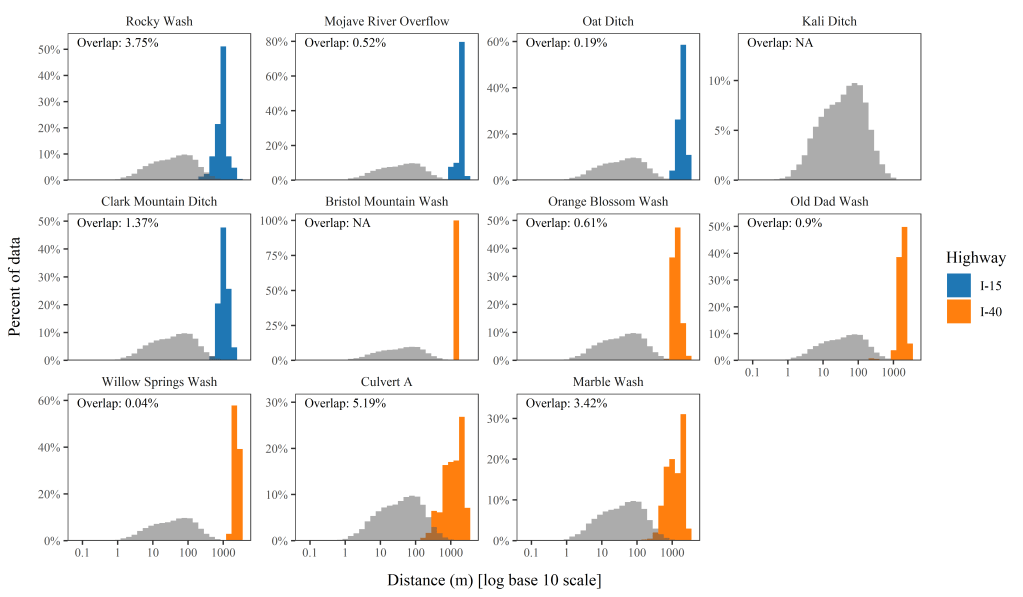
Deployed collars were set to increase fix rate to one location per 30 min when animals came within approximately 1 km of either I-15 or I-40. We first removed locations that occurred when sun angles were below a threshold associated with decreased nighttime movement (as described by Aiello et al. 2023) and then subset the remaining data to 30-min fix locations near highways. We calculated step lengths as the Euclidean distance between all consecutive GPS points and identified the maximum-recorded step length. We then determined the distance from each point to our focal underpasses within a threshold distance set by the maximum step length. We used the Overlapping package in R (Pastore 2018) to calculate the percent overlap between the distribution of distance to underpass and step length distribution for each focal underpass. Overlap would indicate that animals came close enough to underpasses to easily approach and use the structure on the next step.
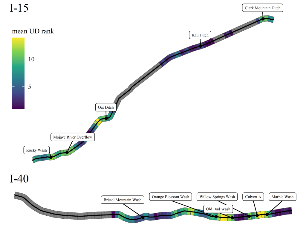
Because the sampled GPS trajectories only reflect a subset of possible bighorn movements within the study region, we also examined the results of model-based movement simulations to assess where desert bighorn would most likely travel near both highways. Aiello et al. (2023) used step selection functions to simulate movement throughout the study area while accounting for habitat preferences and highway avoidance. The collection of simulations run with I-15 and I-40 acting as movement barriers was converted to a utilization distribution raster where each 250 m x 250 m grid cell was given a rank from 1–20 and larger values indicated a higher predicted probability of use by desert bighorn (Aiello et al. 2023). To identify where desert bighorn most likely encountered each highway, we first segmented I-15 and I-40 into sections equal to the average maximum step length per individual (estimated from GPS data described above). We applied a buffer on either side of each segment of the same length and calculated the mean UD value for all cells intersecting the buffer. We examined the mean UD values for segments including a focal underpass, as well as adjacent areas to determine if underpass locations aligned with highly used areas by desert bighorn.
Camera Surveys
Our camera sample design was non-random and targeted to capture desert bighorn sheep using highway underpasses to move between fragmented habitats. We considered 34 structures within the study area and primarily excluded small culverts with height or width < 3 m. We prioritized large, open structures and those closest to rugged terrain or bighorn movements previously recorded by GPS collars or inferred through genetic analyses (Epps et al. 2007, 2018; Creech et al. 2014; Prentice et al. 2018). We selected 11 underpasses with suitable characteristics for bighorn use and deployed 2–4 trail cameras between 1 Nov 2018 and 22 Oct 2021 at each underpass (Fig. 1; Table S1 (PDF)). We affixed cameras to posts approximately 0.5–0.6 m from the ground and serviced and downloaded data approximately every month. Cameras either viewed approach habitat (i.e., faced away from underpass tunnels) on each side of the highway (camera.view = approach), faced culvert openings or spans beneath bridges (camera.view = tunnel), or faced guzzlers added to three sites to encourage underpass use (camera.view = guzzler). Large bridge sites included 4 camera locations: 1 north approach, 1 south approach, and 2 tunnel views (Fig. 1 inset). Smaller culvert sites included one tunnel and 1–2 approach cameras.
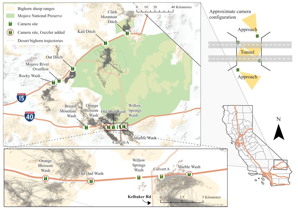
We discontinued camera surveys at Mojave River overflow after repeated theft, leaving 10 remaining sites (I-15 = 4, I-40 = 6). We also discontinued tunnel-view camera deployments at Rocky Wash due to theft early in the study, and instead added a second approach camera that was less visible to tunnel users (an open ATV route passed through this tunnel). We also added a second tunnel view camera set to timelapse on the north side of culvert A for the final year of monitoring. We observed groups of bighorn at the mouth of this culvert in year 1 and 2 and added an additional camera to ensure bighorn culvert use was not missed due to inadequate camera coverage.
Approach cameras were either Browning Strike Force Pro XD or Strike Force HD Pro cameras (Prometheus Group LLC, Birmingham, AL) set to record timelapse videos comprised of images taken every minute during daylight hours. We used timelapse settings for approach cameras to detect animals active near underpasses that could potentially cross under the highway. All timelapse cameras also recorded an image if motion-triggered, but we expected that many animals with the opportunity to use underpasses would not be close enough to trigger sensors. The combination of timelapse and motion-triggered settings allowed us to capture more (though not all) animals with crossing opportunities. Tunnel and guzzler cameras were Bushnell Trophy Cam or NatureView cameras (Bushnell Corporation, Overland Park, KS) set to record an image when motion-triggered, with a 1-second quiet period between triggers. We assumed that animals captured on these cameras represent species that used the associated underpass or guzzler to some extent. We did not use image data to assess whether animals successfully travelled from one side of the highway to the other.
Underpass Manipulations
We selected three underpass sites along I-40 to modify after 1 year of camera surveys. We chose to modify I-40 sites and not I-15 sites because of concerns regarding infectious pathogens within the desert bighorn metapopulation. At the time of the study, genetic and GPS-recorded movements indicated bighorn already interacted across I-40 (Epps et al. 2018; Dekelaita et al. 2023); we assumed that any additional connectivity resulting from added guzzlers would not further contribute to pathogen spread beyond the existing extent of the outbreak. Lab tests of samples acquired during animal capture further confirmed presence of the same strain of Mycoplasma ovipneumoniae (the primary pathogen associated with the outbreak) on both sides of I-40 (Shirkey et al. 2023).
During 13–14 Nov 2019, we installed artificial water sources (guzzlers; Rainmaker Products LLC, Bellingham, WA) at Old Dad Wash, Orange Blossom Wash, and Marble Wash (Fig. 1). We chose guzzler locations at a site based on visibility of the underpass and minimum distance to sloped terrain, while also staying within the highway right-of-way (Fig. 2). We monitored all guzzlers with Browning Strike Force Pro XD or Strike Force HD Pro cameras set to take one image when motion-triggered with a 1-second quiet period between triggers. We installed replacement cameras as needed and serviced cameras approximately monthly until we removed all cameras and guzzlers during 21–22 October 2021.

from the guzzler. We installed guzzlers near 3 of 11 underpasses one year into a 3-year camera survey to increase the chance of desert bighorn sheep finding and using underpasses to cross highways near Mojave National Preserve, CA. C) Example image of mule deer using Clark Mountain Ditch to travel under I-15 and D) Desert bighorn sheep investigating Culvert A after knocking the camera askew. No images documented bighorn further in the culvert than this example.
Camera Data Processing
We used different methods to process timelapse and motion-triggered photo data. We viewed all timelapse videos at half-speed and identified all medium- to large-bodied mammals, excluding humans and domestic dogs travelling with humans. Each reviewer recorded their confidence in the species observed as “certain” or “uncertain”. A second expert reviewer examined all uncertain observations and any observations of bighorn sheep or mule deer (species of similar size and shape that may be confused at a distance), and revised records as needed. We did not identify small mammals or other taxa, and if no bighorn sheep were documented in timelapse videos after reviewing 2 years of data, we did not review year 3 data at those sites to reduce processing time. We created a binary (1/0) matrix describing detection of each species on each active camera-day and summarized camera effort as the total number of camera-days recorded on all reviewed timelapse videos. We excluded any videos or observations from final analyses if the daily timelapse video covered less than 8 hours to ensure that our unit of effort (camera-day) was comparable across the study period.
All motion-triggered photos were loaded into Wildlife Insights (Ahumada et al. 2020) and manually tagged to the lowest taxonomic level possible for all three years of monitoring. We downloaded photo and tag data on 16 Sept 2023 (Aiello et al. 2018). We combined photo data from all cameras at a site for each view (approach, tunnel, guzzler), corrected known timestamp errors, and filtered the data to all identifiable mammal species except humans and domestic dogs with humans. We then reduced the dataset to independent detection events. We considered multiple observations of the same species at a site to be independent events if they occurred at least 1 hour apart. We summarized camera effort for each camera view and site as the total number of active camera-days across all camera deployments. We processed camera observation and effort data, and completed analyses described below using program R (v.4.2.1).
Sample Coverage
Due to varying camera numbers per site, camera and battery failure, user error, and theft, camera effort varied across sites and camera views (Table 1). To determine if the total effort was long enough to detect all species at each site and camera view, we used the R package iNEXT (Hsieh et al. 2016) to estimate sample coverage. Sample coverage ranges between 0–1 and reflects the probability that a newly captured animal would belong to one of the species already documented given the current camera effort and species detection frequencies. Estimates close to or equal to 1 indicate complete coverage of the sampled area. To inform future camera surveys, we calculated the mean ± standard error (SE) of camera-days needed to reach a sample coverage of 0.99 for each camera view.
Table 1. Summary of timelapse (tlapse) and motion-triggered (photo) camera data collected at each underpass site and camera view from 1 Nov 2018–22 Oct 2021. Sites include focal underpasses along highways I-15 and I-40 targeted for potential desert bighorn use near Mojave National Preserve, CA, USA. Camera Views included: approach habitat (i.e., faced away from underpass tunnels) on each side of the highway (approach), culvert openings or spans beneath bridges (tunnel), or guzzlers added to three sites to encourage underpass use (guzzler). Camera Days indicates the number of unique camera-days of active monitoring included in the study. Species Observed refers to the number of unique mammal species identified throughout the study, where all mammal species were identified in photo data and only medium- to large-bodied mammals were identified in timelapse data. Sample Coverage ranges from 0–1 and estimates the probability that a newly documented animal would be a species already detected given the current camera effort and previous detections.
| Hwy | Site | Camera View | Data Type | Camera Days | Species Observed | Sample Coverage |
| I-15 | Clark Mountain Ditch | approach | tlapse | 1494 | 6 | 1 |
| I-15 | Clark Mountain Ditch | approach | photo | 2052 | 5 | 1 |
| I-15 | Clark Mountain Ditch | tunnel | photo | 2095 | 11 | 1 |
| I-15 | Kali Ditch | approach | tlapse | 1331 | 3 | 1 |
| I-15 | Kali Ditch | approach | photo | 1884 | 7 | 1 |
| I-15 | Kali Ditch | tunnel | photo | 2073 | 10 | 1 |
| I-15 | Mojave River Overflow | approach | tlapse | 23 | 0 | NAa |
| I-15 | Mojave River Overflow | approach | photo | 57 | 0 | NAa |
| I-15 | Mojave River Overflow | tunnel | photo | 26 | 0 | NAa |
| I-15 | Oat Ditch | approach | tlapse | 1394 | 2 | 1 |
| I-15 | Oat Ditch | approach | photo | 1910 | 5 | 1 |
| I-15 | Oat Ditch | tunnel | photo | 1973 | 6 | 1 |
| I-15 | Rocky Wash | approach | tlapse | 1687 | 2 | 1 |
| I-15 | Rocky Wash | approach | photo | 1747 | 2 | 1 |
| I-15 | Rocky Wash | tunnel | photo | 242 | 0 | NAa |
| I-40 | Bristol Mountain Wash | approach | tlapse | 1530 | 3 | 1 |
| I-40 | Bristol Mountain Wash | approach | photo | 2057 | 3 | 1 |
| I-40 | Bristol Mountain Wash | tunnel | photo | 2037 | 9 | 1 |
| I-40 | Culvert A | approach | tlapse | 894 | 3 | 1 |
| I-40 | Culvert A | approach | photo | 1030 | 2 | 1 |
| I-40 | Culvert A | tunnel | tlapse | 219 | 3 | 0.802b |
| I-40 | Culvert A | tunnel | photo | 1313 | 11 | 0.997 |
| I-40 | Marble Wash | approach | tlapse | 1912 | 4 | 1 |
| I-40 | Marble Wash | approach | photo | 1942 | 2 | 1 |
| I-40 | Marble Wash | tunnel | photo | 1968 | 6 | 1 |
| I-40 | Marble Wash | guzzler | photo | 566 | 7 | 0.998 |
| I-40 | Old Dad Wash | approach | tlapse | 1859 | 3 | 1 |
| I-40 | Old Dad Wash | approach | photo | 1942 | 5 | 1 |
| I-40 | Old Dad Wash | tunnel | photo | 2123 | 8 | 1 |
| I-40 | Old Dad Wash | guzzler | photo | 491 | 9 | 1 |
| I-40 | Orange Blossom Wash | approach | tlapse | 1812 | 4 | 1 |
| I-40 | Orange Blossom Wash | approach | photo | 1937 | 5 | 1 |
| I-40 | Orange Blossom Wash | tunnel | photo | 2073 | 7 | 1 |
| I-40 | Orange Blossom Wash | guzzler | photo | 445 | 8 | 0.998 |
| I-40 | Willow Springs Wash | approach | tlapse | 1945 | 4 | 1 |
| I-40 | Willow Springs Wash | approach | photo | 2001 | 8 | 1 |
| I-40 | Willow Springs Wash | tunnel | photo | 2078 | 8 | 1 |
a Inadequate data to calculate coverage
b Camera added in year 3
Desert Bighorn Detections
To identify which underpasses had the highest potential for desert bighorn use, we calculated bighorn detections per 100 camera-days (independent observations / camera-days * 100) from approach cameras at each site. We assumed that sites with higher bighorn detection rate on cameras viewing the surrounding habitat have more bighorn active within sight of highway underpasses, and a higher potential for underpass use. We similarly calculated bighorn detection rate for tunnel cameras to determine whether any underpasses were potentially used by bighorn to cross under the highway and if so, how often.
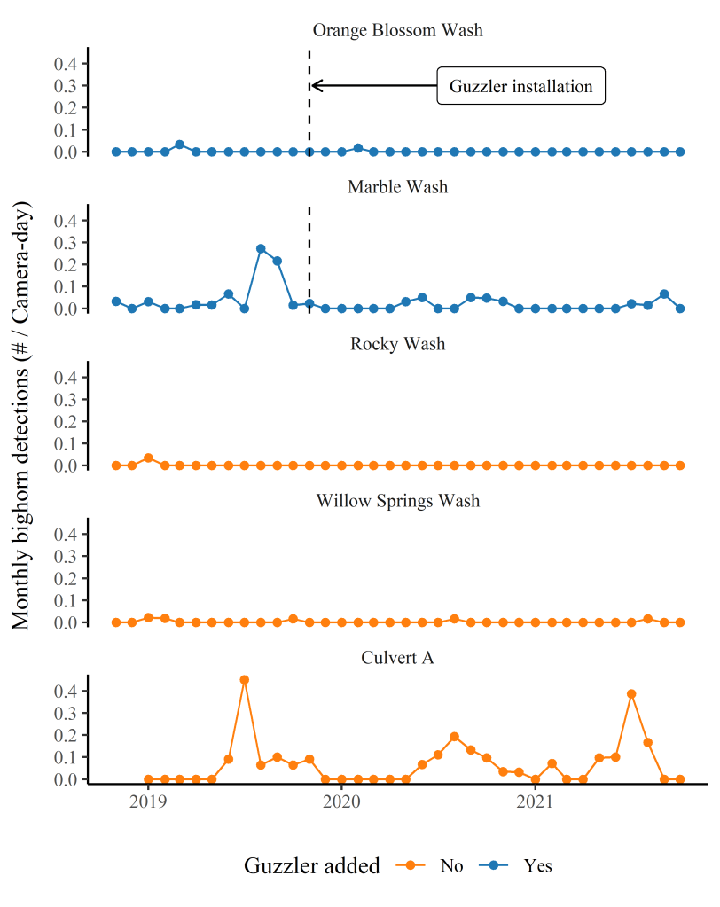
Bighorn Detections Pre- and Post-Guzzler Installation
Due to limited detections of bighorn on tunnel cameras, it was not possible to compare bighorn underpass use relative to guzzler installations. Instead, we assessed the effect of guzzlers on bighorn approach rates. We analyzed monthly bighorn detections from timelapse data relative to guzzler status (guzzler.added = “Yes” or “No”) and guzzler period (guzzler.period = “Year Before”, “Year 1”, or “Year 2”). We used data from all sites with at least one bighorn detection in a Before-After-Control-Impact (BACI) analysis (Wauchope et al. 2021). We considered sites without guzzlers added as controls and those with guzzlers added as impact sites. We analyzed the response variable, monthly bighorn detections, in a negative binomial mixed effects model to account for the right skew in the detection distribution and repeated measures at each site. We included the number of active camera-days as an offset term to account for variable effort, a random intercept for site, and the fixed effects guzzler.added, guzzler.period and their interaction. We used the estimated coefficients (b ± SE) for the interaction terms guzzler.added*guzzler.period and their associated p-values (P) to determine whether bighorn activity responded to the addition of guzzlers at underpasses and in what direction, i.e., was there an increase, decrease, or no change in detection rate relative to the impact. The model was estimated using the package glmmTMB (Arni et al. 2017).
Results
Near-Highway Activity
As previously reported by Aiello et al. (2023), no collared bighorn successfully crossed either highway during the study. We recorded 22,172 near-highway locations for 22 unique individuals. The step lengths recorded for consecutive near-highway points ranged from 0.07 m to 2,644 m with mean 82.4 m, and an average maximum step length per individual of 927 m. Collared desert bighorn came within a single step length to 10 out of 11 focal underpasses (Fig. 3). The distributions of distance to an underpass and step lengths overlapped the most at Culvert A, where desert bighorn GPS locations came as close as 14.5 m to the culvert. Even though collared bighorn rarely came within step length distance of Willow Springs Wash during the study period, the simulated UD suggested a moderate probability of desert bighorn activity near this underpass (mean UD rank = 11.1; Table S1 (PDF)). We could not calculate an overlap metric for Bristol Mountain Wash, as only one GPS point came within a single step length of this site. Kali Ditch had the least evidence of nearby desert bighorn activity; no recorded locations came within the maximum step length of this site and simulation UDs suggested only rare use of the area surrounding the underpass (mean UD rank = 4.21; Table S1 (PDF)). Though many underpasses occurred in areas predicted to have moderate bighorn activity, they were rarely located in the highway segment with the highest UD values of the local area (Fig. 4).
Sample Coverage
We excluded discontinued camera locations (Mojave River Overflow, Rocky Wash tunnel camera) from statistics reported hereafter, but see Table 1 for summary data from all sites. Sample coverage was estimated to be ≥ 0.99 and indicated a high probability that we detected all species using the surveyed area except for the north-side tunnel-view from the culvert A timelapse camera added in the final year of surveys (Table 1). The mean (± SE) of camera-days predicted necessary to reach 0.99 sample coverage based on motion-triggered data was 607 ± 48.0 for approach cameras, 417 ± 35.5 for tunnel cameras, and 55.4 ± 6.74 for guzzler cameras. Timelapse data averaged 976 ± 45.0 video-days to reach 0.99 sample coverage. Our camera effort averaged (± SE) 1850 ± 30.2, 1970 ± 28.0, and 501 ± 20.4 camera-days for motion-triggered data from approach, tunnel and guzzler cameras respectively and 1586 ± 32.7 camera-days for timelapse approach videos. During this time, we documented 16 mammal species across all camera views in motion-triggered photos (approach = 12, tunnel = 16, guzzler = 10) and 7 medium- to large-bodied mammal species in timelapse approach videos (Table S1; Figs. S1–S3 (PDF)).
Desert Bighorn Detections
We observed desert bighorn sheep on approach cameras at 5 of 10 sites and calculated the highest detection rates at culvert A and Marble Wash sites along I-40 (Table 2). All bighorn approach observations occurred on the south side of the highway except for Willow Springs Wash where we observed two north-side approaches and three south-side approaches. We never observed desert bighorn on guzzler camera photos and observed bighorn on tunnel cameras at one site only–culvert A. This tunnel camera faced the opening of the culvert and documented groups of bighorn sheep moving past and occasionally resting within the shade of the culvert mouth on hot summer afternoons (Fig. 2D (PDF)). We recorded 16 independent bighorn events on the culvert A tunnel camera over 1313 camera-days (1.22 detections/100 camera-days). However, after reviewing all images and scanning the area on both sides of the culvert after these events for fecal pellets and tracks, we found no evidence that bighorn actually used the culvert to cross under the highway. During some of these detections, the camera captured GPS-collared animals whose GPS data also showed no evidence of ever crossing the highway. The additional timelapse camera added on the north side of this culvert viewed the tunnel exit and documented three species over 219 camera-days: coyote, grey fox, and bobcat.
Table 2. Desert bighorn sheep detection rates in timelapse videos from underpass sites with at least one bighorn detection. Timelapse videos were recorded by trail cameras that faced approach habitat north and south of underpass openings along highways I-15 and I-40 from 1 Nov 2018–22 Oct 2021. Videos comprised photos taken every minute during daylight hours and were reviewed to record daily detections of medium- to large-bodied mammals. N Detections is the total number of daily desert bighorn detections. We calculated N Detections / reviewed camera-days * 100 to estimate desert bighorn detection rate per 100 camera-days.
| Hwy | Site | Guzzler Added | N Detections | Detections/100 camera-days |
| I-40 | Culvert A | No | 67 | 7.49 |
| I-40 | Marble Wash | Yes | 57 | 2.98 |
| I-40 | Willow Springs Wash | No | 5 | 0.26 |
| I-40 | Orange Blossom Wash | Yes | 2 | 0.11 |
| I-15 | Rocky Wash | No | 1 | 0.06 |
Bighorn Detections Pre- and Post-Guzzler Installation
Of the five sites with bighorn observations on approach cameras, two were sites with guzzler additions and three were sites without guzzler additions (Table 2). We detected few to no bighorn at most times and locations (Fig. 5). The BACI analysis indicated no detectable effect of guzzler installations on monthly approach rates at impact sites when compared to approach rates at control sites (guzzler.addedY * guzzler.periodYear1 interaction term: b = -0.337 ± 0.842 SE, P = 0.689; guzzler.addedY * guzzler.periodYear2 interaction term: b = -1.180 ± 0.846 SE, P = 0.163).
Discussion
A majority of our road infrastructure in the U.S. was built without considering wildlife movement. As a result, the spatial distribution and design of these structures may not align with wildlife preferences and needs. Our multi-year study of non-wildlife underpasses near fragmented desert bighorn habitat suggests the focal structures may only be rarely, if ever, used as movement corridors by this particular species. Despite evidence in both movement and camera data that desert bighorn in the region had opportunities to use non-wildlife underpasses, we documented no concrete evidence of highway crossings via these structures. Meanwhile, we observed other mammal species with less strict habitat preferences including coyote, bobcat, and feral burros, regularly use underpasses. Our results indicate a need for modifications or new structures that better align with desert bighorn movement and behavior if priority genetic or demographic connections are to be strengthened across I-15 and I-40.
In any camera monitoring effort, not detecting a species may be indicative of circumstances other than true absence. A species may be present but missed due to detection error (Jumeau et al. 2017) or may use the site outside of the timeframes of the study (Kays et al. 2020). Jumeau et al. (2017) compared continuous video streams to triggered photo detections of wildlife using small culverts and found motion-triggered images missed 17% of medium-sized mammals observed on videos. They recommend using multiple cameras within the underpass as a means to reduce detection errors. In this study, we used two cameras under large tunnels where possible, but often could not sample the entire tunnel viewshed given the extensive time needed to review camera data streams. Still, our multi-year sampling period resulted in a robust camera effort and our estimated sample coverage indicated a low probability of observing new species not already detected in the dataset. When attempting to observe rare crossing behavior with cameras, our results suggest that intensive and extended sampling effort per site may be required.
Camera studies that target areas near human activity risk theft that can limit attempts to achieve the needed sampling effort. Often researchers sacrifice ideal camera views or sites in addition to time and money in efforts to avoid camera theft (Meek et al. 2018). Easy access and theft along ATV routes limited the temporal and spatial coverage of our cameras. As a result, sampling effort was minimal at Mojave River Overflow and tunnel views of Rocky Wash. We recommend collaboration with local transportation agencies to attach cameras directly to underpass structures out of reach of visitors in regularly accessed areas. Despite incomplete camera surveys at these locations, we similarly expect desert bighorn avoid using these underpasses based on extensive GPS data from animals collared adjacent to these sites throughout 2014–2021 (Prentice et al. 2018; Aiello et al. 2023; Dekelaita et al. 2023).
Our low rate of desert bighorn detections and lack of confirmed underpass use mirrors the results of other underpass studies where focal structures were not designed for bighorn sheep. Murphy-Mariscal et al. (2015) similarly documented bighorn sheep near underpasses along highways fragmenting habitat, but never using them, despite documented use by other large mammals like mule deer and mountain lion. Numerous studies of underpasses in Arizona suggest that tunnel openness and location may largely affect the frequency of bighorn use (Crabb and Bristow 2015; Gagnon et al. 2017, 2022); pre-existing structures that lack the ideal combination of these two factors tend not to be used or are used rarely by rams, which are more prone to risk-taking and inter-mountain movements than ewes (Bleich et al. 1997; Dekelaita et al. 2023). Many ungulate species appear to be sensitive to structural details and prefer underpasses with open characteristics (wide and/or tall spaces with short tunnels) (Denneboom et al. 2021; Jensen et al. 2022). In our study area, we found that underpasses located in more appropriate habitat for bighorn were often smaller structures with long tunnels like culvert A (Table S1, Figs. 2D and 4), and thus were less suitable for bighorn.
Movement toward a high-disturbance area along a busy roadside is a risky behavior that may or may not result in access to novel resources. Less-than-ideal underpass structures may be perceived as more dangerous and tip the scales in favor of staying put. Trade-offs between risks and rewards have been documented in several ungulate species, including desert bighorn (Bleich et al. 1997; Leblond et al. 2007; Lowrey et al. 2019; Poulin et al. 2023). If bighorn perceive available underpasses as high-risk areas, crossings may be more likely when local resources (water, forage, or mates) are absent or in decline, and incentives strong enough to outweigh the risks (Bleich et al. 2016). Though conditions during our study did not trigger observable underpass use, roadkill observed nearby suggest local bighorn were not wholly avoiding risky travel between fragmented habitat. During the study, two uncollared rams died attempting to cross I-15 and I-40 at-grade; both carcasses were found within 760 and 240 m of a monitored underpass (Aiello et al. 2023). Reported roadkill rates largely underestimate actual wildlife-vehicle collision and wildlife crossing rates (Huijser et al. 2008), so these events may indicate additional crossing attempts, and enough incentive to risk movement across a major highway.
Of the monitored underpasses, Willow Springs Wash had the best (though still not ideal) combination of location, terrain, and bridge characteristics to encourage bighorn use. We documented bighorn approaching this bridge from both sides, and the slightly larger bridge opening may be enough for less-wary rams. Indeed, GPS collared bighorn—both male and female—may have used this structure to cross I-40 multiple times in 2015, though the data resolution was too coarse to confirm these as underpass or at-grade crossings (Prentice et al. 2018). Successful use of the Willow Springs bridge, however, does not avoid road crossings entirely; bighorn would need to cross another smaller road (Kelbaker Rd) to complete their travel between preferred habitat. Kelbaker Road is a two-lane 55 mph road used to access Mojave National Preserve and Mojave Trails National Monument, as well as to travel between Southern California cities and Las Vegas. Bleich et al. (2016) observed both male and female bighorn successfully cross sections of Kelbaker Road within the preserve from 1986 – 1990, but annual traffic counts on Kelbaker have tripled since the late 1990s, despite extended road closures in recent years (NPS, https://irma.nps.gov, accessed 19 Jan 2024). Notably, vehicle strikes have killed bighorn attempting to cross Kelbaker Rd while moving between rocky hillsides near Willow Springs Wash (CDFW, unpub. data). Even if bighorn currently use this underpass to move under I-40, relying on this crossing structure alone for connectivity continues to risk vehicle-caused mortality as well as driver safety near the intersection of I-40 and Kelbaker Rd.
Our efforts to attract bighorn to crossing structures with new water sources did not prove effective within the timeframe of this study. Extensive research shows that water sources influence desert bighorn movement and distribution (Epps et al. 2004; Longshore et al. 2009; Bleich et al. 2010; Glass et al. 2022), and availability of influential resources can promote tolerance of human disturbed areas (Anderson et al. 2017; Lowrey and Longshore 2017). We suspect bighorn along I-40 may need more time to locate and use new guzzlers or may have little incentive to use them if preferred water sources are nearby. Desert bighorn can adapt to novel water sources within weeks to months of their availability (Campbell and Remington 1979; Leslie and Douglas 1979), but acclimation rates appear highly variable and can take up to 3–7 years (Gunn 2000; N. W. Darby, NPS, unpublished data). Over longer timeframes, water near underpasses may increase crossings, but we saw no positive trend of this approach after two years.
Where increased connectivity is desired, we recommend construction of new or highly modified crossing structures at regularly approached locations in combination with fencing to funnel animals toward crossing structures (Dodd et al. 2007). Of all our sites, bighorn approached culvert A most often, and have attempted to cross I-40 at-grade at this location. Bighorn regularly move past this structure to access an important water source, yet we suspect they do not use the culvert due to its long and small tunnel. Converting this culvert to a large open underpass or ideally building an overpass at this location in combination with fencing along I-40 between Willow Springs and Marble Wash would surely improve safe passage rates for bighorn. In other areas of our study, bighorn approach rates were lower—possibly due to poor location relative to bighorn habitat preferences (Fig. 4). Efforts to improve connectivity in these areas should locate structures closer to predicted bighorn movement corridors (Aiello et al. 2023), and ideally build overpasses instead of underpasses to facilitate both ewe and ram use that would allow for both gene flow and re-colonization events (Creech et al. 2014). Gagnon et al. (2022) demonstrated that carefully located and designed wildlife crossing structures can result in movement across highways that far exceeds crossing and roadkill rates observed without mitigation. Bighorn connectivity in our study region has similar potential – simulations estimate that movement rates between habitat fragmented by I-15 and I-40 could be three times higher without highway barriers than present conditions (Aiello et al. 2023). Future actions to improve the design and location of available crossing structures can help alleviate some of these connectivity losses.
Acknowledgements
Funding for this study was provided by the NPS (PMIS 195577) and CDFW. CMA received additional support from the National Park Foundation Science Fellowship. We thank A. Evans, R. Ianniello, L. Harrison, A. Joyce, M. Ogawa, M. Burchett and A. Calton for maintaining cameras and guzzlers throughout the study and S. Gibson for assisting with site scouting. We thank the many students, interns, and volunteers that processed camera data–a full list of contributing individuals can be found at https://dbsconnect.weebly.com/team.html. Finally, we thank the members of the public that encountered our cameras and kindly left these devices alone to collect the data for this study.
Literature Cited
- Ahumada, J. A., E. Fegraus, T. Birch, N. Flores, R. Kays, T. G. O’Brien, J. Palmer, S. Schuttler, J. Y. Zhao, W. Jetz, M. Kinnaird, S. Kulkarni, A. Lyet, D. Thau, M. Duong, R. Oliver, and A. Dancer. 2020. Wildlife Insights: a platform to maximize the potential of camera trap and other passive sensor wildlife data for the planet. Environmental Conservation 47:1–6. https://doi.org/10.1017/S0376892919000298
- Aiello, C. M., N. L. Galloway, K. Fratella, P. Prentice, N. W. Darby, D. Hughson and C.W. Epps. 2018. Enhancing function of an increasingly fragmented metapopulation of desert bighorn sheep. Last updated September 2023. Available from: http://n2t.net/ark:/63614/w12003007 (Accessed via wildlifeinsights.org: 16 September 2023).
- Aiello, C. M., N. L. Galloway, P. R. Prentice, N. W. Darby, D. Hughson, and C. W. Epps. 2023. Movement models and simulation reveal highway impacts and mitigation opportunities for a metapopulation-distributed species. Landscape Ecology 38:1085–1103. https://doi.org/10.1007/s10980-023-01600-6
- Anderson, D. J., J. T. Villepique, and V. C. Bleich. 2017. Resource selection by desert bighorn relative to limestone mines. Desert Bighorn Council Transactions 54:13–30.
- Arni M., H. J. Skaug, A. Nielsen, C. W. Berg, K. Kristensen, M. Maechler, K. J. van Bentham, B. M. Bolker and M. E. Brooks. 2017. glmmTMB: Generalized Linear Mixed Models using Template Model Builder. R package v.0.1.3. Available from: https://github.com/glmmTMB
- Bleich, V. C., R. T. Bowyer, and J. D. Wehausen. 1997. Sexual segregation in mountain sheep. Wildlife Monographs 134:3–50.
- Bleich, V. C., J. P. Marshal, and N. G. Andrew. 2010. Habitat use by a desert ungulate: predicting effects of water availability on mountain sheep. Journal of Arid Environments 74:638–645. http://dx.doi.org/10.1016/j.jaridenv.2009.10.019
- Bleich, V. C., J. C. Whiting, J. G. Kie, and R. T. Bowyer. 2016. Roads, routes, and rams: does sexual segregation contribute to anthropogenic risk in a desert-dwelling ungulate? Wildlife Research 43:380–388. http://dx.doi.org/10.1071/WR15231
- California Department of Fish and Wildlife (CDFW). 2022. Restoring California’s Wildlife Connectivity. A report prepared by California Department of Fish and Wildlife, Biogeographic Data Branch, Sacramento, CA, USA. https://nrm.dfg.ca.gov/FileHandler.ashx?DocumentID=204648&inline
- Campbell, B. H. and R. Remington. 1979. Bighorn use of artificial water sources in the Buckskin Mountains, Arizona. Desert Bighorn Council Transactions 23:50–56.
- Carr, L. W., L. Fahrig, and S. E. Pope. 2002. Impacts of landscape transformation by roads. Pages 225–243 in K. J. Gutzwiller, editor. Applying Landscape Ecology.
- Clevenger, A. P. and M. P. Huijser 2011. Wildlife Crossing Structure Handbook: Design and Evaluation in North America. A report prepared by Western Transportation Institute for the Federal Highway Administration, Washington, D.C., USA. https://rosap.ntl.bts.gov/view/dot/41646
- Crabb, M., and K. Bristow. 2015. Trans-highway movements and use of underpasses by desert bighorn sheep. Desert Bighorn Council Transactions 53:1–23.
- Creech, T. G., C. W. Epps, R. J. Monello, and J. D. Wehausen. 2014. Using network theory to prioritize management in a desert bighorn sheep metapopulation. Landscape Ecology 29:605–619. https://doi.org/10.1007/s10980-014-0016-0
- Dekelaita, D. J., C. W. Epps, D. W. German, J. G. Powers, B. J. Gonzales, R. K. Abella-Vu, N. W. Darby, D. L. Hughson, and K. M. Stewart. 2023. Animal movement and associated infectious disease risk in a metapopulation. Royal Society Open Science 10:220390. https://doi.org/10.1098/rsos.220390
- Denneboom, D., A. Bar-Massada, and A. Shwartz. 2021. Factors affecting usage of crossing structures by wildlife—a systematic review and meta-analysis. Science of the Total Environment 777:146061. https://doi.org/10.1016/j.scitotenv.2021.146061
- Epps, C. W., R. S. Crowhurst, and B. S. Nickerson. 2018. Assessing changes in functional connectivity in a desert bighorn sheep metapopulation after two generations. Molecular Ecology 27:2334–2346. https://doi.org/10.1111/mec.14586
- Epps, C. W., D. R. McCullough, J. D. Wehausen, V. C. Bleich, and J. L. Rechel. 2004. Effects of climate change on population persistence of desert-dwelling mountain sheep in California. Conservation Biology 18:102–113. https://doi.org/10.1111/j.1523-1739.2004.00023.x
- Epps, C. W., P. J. Palsbøll, J. D. Wehausen, G. K. Roderick, and D. R. McCullough. 2006. Elevation and connectivity define genetic refugia for mountain sheep as climate warms. Molecular Ecology 15:4295–4302. https://doi.org/10.1111/j.1365-294X.2006.03103.x
- Epps, C. W., P. J. Palsbøll, J. D. Wehausen, G. K. Roderick, R. R. Ramey, and D. R. McCullough. 2005. Highways block gene flow and cause a rapid decline in genetic diversity of desert bighorn sheep. Ecology Letters 8:1029–1038. https://doi.org/10.1111/j.1461-0248.2005.00804.x
- Epps, C. W., J. D. Wehausen, V. C. Bleich, S. G. Torres, and J. S. Brashares. 2007. Optimizing dispersal and corridor models using landscape genetics. Journal of Applied Ecology 44:714–724. https://doi.org/10.1111/j.1365-2664.2007.01325.x
- Gagnon, J. W., C. D. Loberger, K. S. Ogren, S. C. Sprague, and S. R. Boe. 2017. Evaluation of desert bighorn sheep movement along Interstate-15; Virgin River Gorge. A report prepared by Arizona Game and Fish Department Wildlife Contracts Branch for Arizona Department of Transportation, Phoenix, AZ, USA. JPA 13-0001315-I. https://apps.azdot.gov/files/ADOTLibrary/publications/project_reports/pdf/spr710.pdf
- Gagnon, J. W., C. D. Loberger, K. S. Ogren, S. C. Sprague, S. R. Boe, and R. E. Schweinsburg. 2022. Mitigating bighorn sheep–vehicle collisions and habitat fragmentation with overpasses and adaptive mitigation. Human–Wildlife Interactions 16:1–20. https://doi.org/10.26077/75d5-0905
- Glass, D. G., P. R. Prentice, A. D. Evans, and O. J. Schmitz. 2022. Local differences in maximum temperature determine variation in water use among desert bighorn sheep populations. Journal of Wildlife Management 86:e22313. https://doi.org/10.1002/jwmg.22313
- Glista, D. J., T. L. DeVault, and J. A. DeWoody. 2009. A review of mitigation measures for reducing wildlife mortality on roadways. Landscape and Urban Planning 91:1–7. https://doi.org/10.1016/j.landurbplan.2008.11.001
- Gunn, J. 2000. Justification for the continued use of wildlife water developments for the management of bighorn sheep populations in the southwest United States. Southwest Natural Resource Management Consultants, Mesa, AZ, USA. https://www.adbss.org/files/adbss_water_just_JGunn.pdf
- Huijser, M. P., P. McGowen, J. Fuller, A. Hardy, A. Kociolek, A. P. Clevenger, D. Smith and R. Ament. 2008. Wildlife–Vehicle Collision Reduction Study: Report to Congress. U.S. Department of Transportation, Federal Highway Administration, Washington D.C., USA. https://www.fhwa.dot.gov/publications/research/safety/08034/
- Hsieh, T. C., K. H. Ma, and A. Chao. 2016. iNEXT: an R package for rarefaction and extrapolation of species diversity (Hill numbers). Methods in Ecology and Evolution 7:1451–1456. https://doi.org/10.1111/2041-210X.12613
- Jensen, A. J., J. D. Perrine, A. Schaffner, R. Brewster, A. J. Giordano, M. Robertson, and N. Siepel. 2022. Mammal use of undercrossings is influenced by openness and proximity to riparian corridors. Wildlife Research 50:495–506. https://doi.org/10.1071/WR21183
- Jumeau, J., L. Petrod, and Y. Handrich. 2017. A comparison of camera trap and permanent recording video camera efficiency in wildlife underpasses. Ecology and Evolution 7:7399–7407. https://doi.org/10.1002/ece3.3149
- Kays, R., B. S. Arbogast, M. Baker-Whatton, C. Beirne, H. M. Boone, M. Bowler, S. F. Burneo, M. V. Cove, P. Ding, S. Espinosa, A. L. S. Gonçalves, C. P. Hansen, P. A. Jansen, J. M. Kolowski, T. W. Knowles, M. G. M. Lima, J. Millspaugh, W. J. McShea, K. Pacifici, A. W. Parsons, B. S. Pease, F. Rovero, F. Santos, S. G. Schuttler, D. Sheil, X. Si, M. Snider, and W. R. Spironello. 2020. An empirical evaluation of camera trap study design: How many, how long and when? Methods in Ecology and Evolution 11:700–713. https://onlinelibrary.wiley.com/doi/full/10.1111/2041-210X.13370
- Leblond, M., C. Dussault, J.-P. Ouellet, M. Poulin, R. Courtois, and J. Fortin. 2007. Management of roadside salt pools to reduce moose‐vehicle collisions. Journal of Wildlife Management 71:2304–2310. https://doi.org/10.2193/2006-459
- Leslie, D. M., and C. L. Douglas. 1979. Desert bighorn of the River Mountains, Nevada. Wildlife Monographs 66:3–56.
- Longshore, K. M., C. Lowrey, and D. B. Thompson. 2009. Compensating for diminishing natural water: predicting the impacts of water development on summer habitat of desert bighorn sheep. Journal of Arid Environments 73:280–286. http://dx.doi.org/10.1016/j.jaridenv.2008.09.021
- Lowrey, C., and K. M. Longshore. 2017. Tolerance to disturbance regulated by attractiveness of resources: a case study of desert bighorn sheep within the River Mountains, Nevada. Western North American Naturalist 77:82–98. https://doi.org/10.3398/064.077.0109
- Lowrey, C., K. M. Longshore, D. M. Choate, J. R. Nagol, J. Sexton, and D. Thompson. 2019. Ecological effects of fear: how spatiotemporal heterogeneity in predation risk influences mule deer access to forage in a sky-island system. Ecology and Evolution 9:7213–7226. https://doi.org/10.1002/ece3.5291
- Meek, P. D., G. A. Ballard, J. Sparkes, M. Robinson, B. Nesbitt, and P. J. S. Fleming. 2018. Camera trap theft and vandalism: occurrence, cost, prevention and implications for wildlife research and management. Remote Sensing in Ecology and Conservation 5(2):160–168. https://doi.org/10.1002/rse2.96
- Murphy-Mariscal, M. L., C. W. Barrows, and M. F. Allen. 2015. Native wildlife use of highway underpasses in a desert environment. Southwestern Naturalist 60:340–348.
- Ng, S. J., J. W. Dole, R. M. Sauvajot, S. P. D. Riley, and T. J. Valone. 2004. Use of highway undercrossings by wildlife in southern California. Biological Conservation 115:499–507. https://doi.org/10.1016/S0006-3207(03)00166-6
- Pastore, M. 2018. Overlapping: an R package for estimating overlapping in empirical distributions. Journal of Open Source Software 3:1023. https://doi.org/10.21105/joss.01023
- Poulin, M. P., S. G. Cherry, and J. A. Merkle. 2023. Dynamic balancing of risks and rewards in a large herbivore: further extending predator–prey concepts to road ecology. Journal of Animal Ecology 92:1954–1965. https://doi.org/10.1111/1365-2656.13985
- Prentice, P., A. Evans, D. Glass, R. Ianniello, and T. Stephenson. 2018. Desert Bighorn Sheep Status Report, November 2013 to October 2016. A report prepared by the California Department of Fish and Wildlife, Inland Deserts Region, Bishop, CA, USA. https://nrm.dfg.ca.gov/FileHandler.ashx?DocumentID=175172
- Rytwinski, T., and L. Fahrig. 2015. The impacts of roads and traffic on terrestrial animal populations. Pages 237–246 in R. van der Ree, D. J. Smith, and C. Grilo, editors. Handbook of Road Ecology. John Wiley & Sons, Ltd, West Sussex, UK. https://doi.org/10.1002/9781118568170.ch28
- Schwartz, O. A., V. C. Bleich, and S. A. Holl. 1986. Genetics and the conservation of mountain sheep Ovis canadensis nelsoni. Biological Conservation 37:179–190.
- Shirkey, N., A. Roug, T. Besser, V. C. Bleich, N. Darby, D. Dekelaita, N. L. Galloway, B. Gonzales, D. Hughson, L. Konde, R. Monello, P. R. Prentice, R. Vu, J. Wehausen, B. Munk, J. Powers, and C. W. Epps. 2021. Previously unrecognized exposure of desert bighorn sheep (Ovis canadensis nelsoni) to Mycoplasma ovipneumoniae in the California Mojave Desert. Journal of Wildlife Diseases 57:447–452. https://doi.org/10.7589/JWD-D-20-00098
- Thomas, K. A., C. I. P. Falvo, K. D. Enns, T. M. Bell, and A. L. Everette. 2018. Central Mojave Desert Vegetation Mapping Project, California, 1997–1999. U.S. Geological Survey data release. Available from: https://doi.org/10.5066/P9OUBE6T (Accessed 22 Oct 2020)
- U.S. Departments of the Interior (USDOI), U.S. Department of Agriculture, U.S. Departmnet of Commerce, and Council on Environmental Quailty. 2021. Conserving and Restoring America the Beautiful. Premilinary report to the National Climate Taks Force, Washington, D.C., USA. https://www.doi.gov/sites/doi.gov/files/report-conserving-and-restoring-america-the-beautiful-2021.pdf
- Wauchope, H. S., T. Amano, J. Geldmann, A. Johnston, B. I. Simmons, W. J. Sutherland, and J. P. G. Jones. 2021. Evaluating impact using time-series data. Trends in Ecology and Evolution 36:196–205. https://doi.org/10.1016/j.tree.2020.11.001
- Wilson, R. 2023. Wildlife crossings proving their worth. North Dakota Outdoors 9:16–19. https://gf.nd.gov/magazine/2023/may/wildlife-crossings-proving-their-worth